7 Ellesmere Port
National policy
7.1 Local Plans should promote sustainable patterns of development to meet the development needs of their area; align growth and infrastructure; improve the environment; mitigate climate change (including by making effective use of land in urban areas) (NPPF, paragraph 11).
7.2 The Local Plan should encourage sustainable economic growth, set criteria, and identify strategic sites, for local and inward investment to match the strategy and to meet anticipated needs over the plan period (NPPF, paragraph 86b). Planning policies and decisions should recognise and address the specific locational requirements of different sectors (NPPF, paragraph 87).
Evidence base
- Economic Needs Assessment (2025)
- Cheshire West and Chester Property Review (2025)
- Retail Study (in preparation)
- Employment Areas Survey (2024)
- Places Background Paper (2024)
- Land Availability Assessment (Stage One) (Stage Two in preparation)
- Origin Investment Prospectus
- Cheshire and Warrington Local Industrial Strategy
- Inclusive Economy Strategy
- Climate Emergency Response Plan and Land Action Plan
Key issues
- Ellesmere Port is one of four main urban areas in the borough, it is the second largest settlement and most industrialised part of the borough. The Places Background Paper provides a profile of Ellesmere Port.
- The Employment Areas Survey (2024) shows Ellesmere Port has the most business/industrial parks in the borough, including large scale strategic employment locations for specialist industries or sectors, including waste and energy.
- National planning practice guidance states policies should consider the specific locational requirements of specialist or new sectors and logistics. Decarbonisation of industry is taking place and emerging sectors include low carbon/green technologies and hydrogen.
- Housing development is taking place on Ledsham Road allocation, identified in Local Plan (Part One) policy STRAT 4. Elsewhere housing has been developed on former vacant industrial land such as at Rossfield Park and Cromwell Road.
- Ellesmere Port is bounded by Green Belt, which currently restricts further development on the edge of the settlement. Current Local Plan policy encourages the regeneration of vacant, brownfield sites within the settlement boundary.
- Regeneration of Ellesmere Port town centre is taking place; the new Public Services Hub building was completed 2022, transformation of the Market Hall is being progressed through Levelling Up funding. The proximity of Cheshire Oaks means that the town centre is mainly a local shopping function, whereas Cheshire Oaks is a significant out of town retail and leisure destination.
- Ellesmere Port has good transport connections and multi modal opportunities, given its location on the Manchester Ship Canal, rail and motorway networks.
- Ellesmere Port is located adjacent to the Mersey Estuary SPA/Ramsar site, so there is a need to ensure there are no unacceptable impacts on the area's national and internationally designated sites.
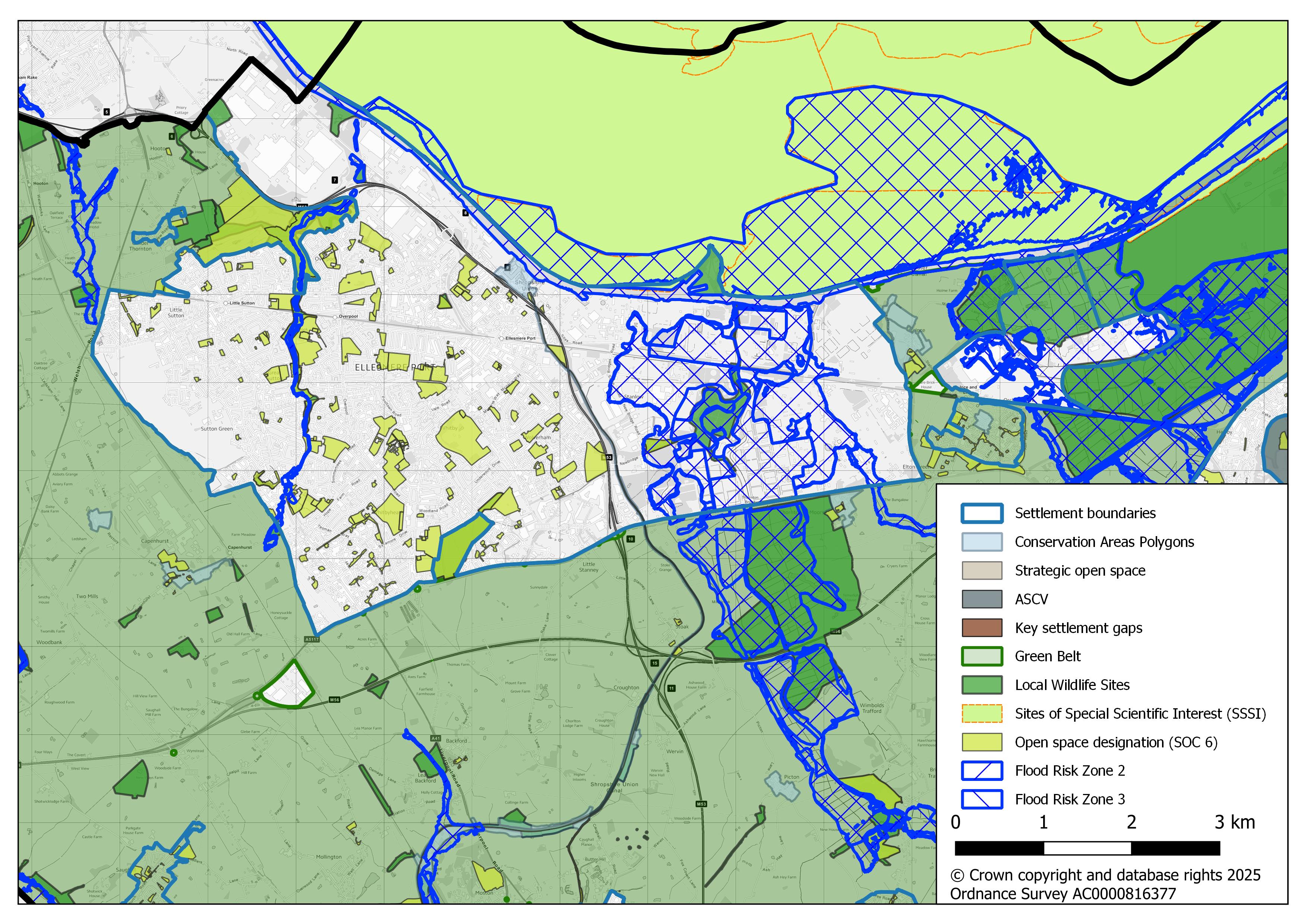
Map 7.1 Ellesmere Port settlement area and key constraints (View full image)
Current adopted policy
| Local Plan | Policy reference | Policy summary |
|---|---|---|
| Local Plan (Part One) | STRAT 4 Ellesmere Port |
Supports substantial economic growth for employment uses, makes provision for 4800 new dwellings to 2030. Key sites include; Ledsham Road (housing 2000 dwellings); New Bridge Road (industrial and business); Stanlow (petrochemicals and related industries); Ince Park (multi-modal resource recovery park and energy from waste); Hooton Park (automotive and related industries); Historic Canal Port (tourism). Makes provision for transport and other infrastructure improvements. Freight transport by rail or the Manchester Ship Canal is supported. |
| Local Plan (Part One) | ECON 1 Economic growth, employment and enterprise |
Key economic sites in Ellesmere Port are identified as; Hooton Park, Ince Park, New Bridge Road, Stanlow. |
| Local Plan (Part Two) | EP 1 Ellesmere Port settlement area |
Sets criteria for all developments. Pedestrian links and new railway crossing and public services hub supported on policies map. |
| Local Plan (Part Two) | EP 2 Employment land provision in Ellesmere Port |
Identifies the employment land allocations in Ellesmere Port, to meet the strategic development requirements of Local Plan (Part One) policy STRAT 2. Site specific criteria included in policies EP 2.A-H. |
| Local Plan (Part Two) | EP 3 Stanlow special policy area |
The Stanlow oil refinery is of national importance and safeguarded for continued use for petrochemical and related industries. Sets criteria for the redevelopment of any vacant, under-used or derelict land for employment use. (Policy boundary includes New Bridge Road). |
| Local Plan (Part Two) | EP 4 Hooton Park |
Sets site specific criteria for developments in Hooton Park. |
| Local Plan (Part Two) | EP 5 Thornton Science Park |
Identifies a specific area within the Stanlow Special Policy Area, for research and development uses. |
| Local Plan (Part Two) | EP 6 Ince Park |
Sets site specific criteria for developments in Ince Park., for a multi-modal resource recovery park and energy from waste facility for use in connection with the recycling, recovery and reprocessing of waste materials. |
| Local Plan (Part Two) | EP 7 Ellesmere Port historic canal port |
Supports tourism development and sets criteria for development within the historic canal port. |
| Local Plan (Part Two) | T 5 Parking and access |
Sets criteria for safe access to new development sites for all users and the provision and protection of sufficient parking to service the needs of development, with regard to the Council’s latest adopted parking standards. |
Suggested policy approach
7.3 The suggested policy approach is to combine Local Plan (Part One) policy STRAT 4 with Local Plan (Part Two) policy EP 1. The public services hub (‘The Portal’ building) has been developed and the allocation will be removed from the policies map. The regeneration of Ellesmere Port town centre will be supported.
7.4 The approach to the level of development will depend on the spatial strategy option that is chosen as set out in SS 5 ‘Spatial strategy options’ . This will identify key locations for new housing and employment development in Ellesmere Port. It may mean areas outside of existing settlements are explored for large scale industrial use, or new residential development.
7.5 Ellesmere Port is surrounded by Green Belt and the spatial strategy chosen will determine whether these policies should be amended/updated to reflect national planning policy. The Urenco Capenhurst Technology Park is located on the outskirts of Ellesmere Port and is currently identified as a commercial site in the Green Belt under Local Plan (Part Two) policy GBC 1 and GBC1.E. Key sites with considerable potential to achieve future economic growth are located in the ‘Origin’ area, this includes land in Stanlow (Local Plan (Part Two) policy EP 3 and also includes Thornton Science Park (Local Plan (Part Two) policy EP 5)); Hooton Park (Local Plan (Part Two) policy EP4); and Protos (formerly Ince Park) (Local Plan (Part Two) policy EP 6). These Local Plan (Part Two) policies will be reviewed to ensure they are up to date and reflect the consented uses or development proposals in these areas. It is intended to merge Local Plan (Part Two) policies EP 3 and EP 5, to a single Stanlow and Thornton Science Park policy.
7.6 The new Local Plan will update employment land allocations, and either retain, replace or identify new employment land allocations to meet borough wide needs. It will also update the use classes to reflect new Class E(g) Commercial Business and Service class. These will replace Local Plan (Part Two) policy EP 2.A-H at later stages of preparation of the new Local Plan.
7.7 Alongside locations for new large scale industrial/ warehousing development (linked to the plan strategy), other smaller local employment areas will remain important to the overall mix of land and premises, to provide for a wide range of sizes and types of business. The CF Fertilisers plant announced closure in 2022 and is a large scale redundant previously developed site and regeneration/redevelopment opportunity.
7.8 In line with the Council's Climate Emergency Response Plan, the policy approach will support the low carbon energy transition and decarbonisation of heavy industry.
7.9 The approach towards the historic canal port and National Waterways Museum is set out in sections 18 ‘Visitor economy’ and 26 ‘Historic environment’.
EP 1
Ellesmere Port
Development in Ellesmere Port has the potential to deliver substantial economic growth, through continued and new investment in the Origin area, the reuse/redevelopment of vacant or redundant sites and the regeneration of the town centre. Further housing will be delivered to complement the settlement’s role as a key employment location and support the vitality of the town centre.
The new Local Plan will set out the level and location of new development and regeneration, economic growth, industrial decarbonisation and new housing will be priorities.
Key allocations/ policies
Locations will be identified to deliver strategic development needs for new housing and employment development, linked to section 5 ‘Spatial strategy’ of the Plan.
Ellesmere Port Origin is a strategic employment cluster with four distinct zones;
- Western Advanced Manufacturing Zone; Automotive and related industries, logistics and distribution (covering current Hooton Park Local Plan (Part Two) policy EP 4 and adjacent areas)
- Central industrial area; industrial and warehousing development (M53 corridor, includes New Bridge Road and Stanlow West in current Local Plan (Part One) policy ECON 1)
- Stanlow and Thornton; important for petrochemical and related industries, low carbon technology, research and development (Stanlow operational areas and Thornton Science Park, current Local Plan (Part Two) policies EP 4 and EP 5)
- Eastern Growth Zone; glass manufacturing, environmental and low-carbon technology, energy and waste resource recovery (Encirc, Protos current Local Plan (Part Two) policy EP 6, and former CF Fertilisers site excluding Green Belt and countryside locations)
Urenco and Capenhurst Technology Park: located in the Green Belt, close to the Ellesmere Port settlement boundary. The chosen spatial strategy will determine whether Green Belt boundaries will be amended, it is proposed to retain a policy for the site to allow for a continuation of current uses and for operational improvements within the site.
The approach to the use, design and location of developments in proximity to hazardous installations or pipelines is set out in section 21 ‘Health and wellbeing’. In exceptional cases it may be necessary to strike a balance between the need for investment and regeneration within the existing urban area and the degree of risk involved.
Transport and Infrastructure
Subject to TA 2 ‘Key local transport infrastructure priorities’ the suggested policy approach will identify the key transport priorities for Ellesmere Port, which may include:
- Maximising opportunities for freight transport on the rail network or via the Manchester Ship Canal
- Encouraging new links to rail and waterway networks
- Supporting improved transport links (including pedestrian and cycle) between the town centre, the Waterfront, Stanlow and Rossfield Park
Appropriate provision should be made for access and parking in line with a review of parking standards and parking zones as set out in TA 1 ‘Transport and accessibility’, where there is a concentration of services, increased sustainable transport options and lower levels of car ownership.
All developments will be required to support physical and landscape improvements to the gateways, corridors and green spaces within Ellesmere Port including along the M53/Shropshire Union Canal Corridor.
Question EP 1
Do you agree with the suggested policy approach towards Ellesmere Port, as set out in EP 1 ‘Ellesmere Port’ above? If not please suggest how it could be amended?
Question EP 2
Do you have any comments on the use of previously developed land within Ellesmere Port?
EP 2
Origin - Stanlow and Thornton Science Park
Land at Stanlow (to be identified on the policies map) will be safeguarded for nationally significant petrochemical and related industries.
New developments are encouraged to support the low carbon energy transition, and where appropriate include measures to decarbonise heavy industrial processes (see section 28 ‘Energy’ and approach to low carbon fuel). The redevelopment of any surplus vacant, under-used or derelict land for employment or related sui generis uses will be supported.
All development proposals must include public safety and security measures and will be required to meet health and safety advice.
Proposals involving freight movements, warehousing and logistics should maximise opportunities to transport products by non-road modes of transport including the Manchester Ship Canal and rail network.
Development must minimise and mitigate any impacts on the local environment, health, residential amenity, potential for pollution, noise generation, visual impact and flood risk.
Thornton Science Park is located within Stanlow and identified for research and development. The central landscape area is important for the character and quality of the science park and should be retained and enhanced with any development proposals.
Question EP 3
Do you agree with the suggested policy approach towards Origin - Stanlow and Thornton Science Park, as set out in EP 2 ‘Origin - Stanlow and Thornton Science Park’ above? If not please suggest how it could be amended?
Question EP 4
Do you have any comments on the use of previously developed land within Origin - Stanlow and Thornton Science Park?
EP 3
Origin - Protos
Land at Protos (to be identified on the policies map) will be safeguarded for the following;
- Multi-modal development in connection with resource recovery and waste, reducing carbon emissions and sustainable energy generation. See sections 29 ‘Managing waste’ and 28 ‘Energy’.;
- Existing and planned port and rail infrastructure, to maximise opportunities for freight movements on the Manchester Ship Canal or rail network and safeguard minerals infrastructure
The current policies map will be reviewed and where necessary updated in line with extant consented developments at Protos.
The policy approach will seek to ensure development is comprehensively planned and takes account of other operational, planned or consented development in Origin and the surrounding area.
The ecological mitigation areas and landscaping that form part of the consented resource recovery park are retained. See section 25 ‘Green infrastructure, biodiversity and geodiversity’
Development should make provision for public access (including public transport), having regard to operational needs of businesses and public safety.
Development must minimise and mitigate any local impacts on the local environment, health, residential amenity, potential for pollution, noise generation, visual impact and flood risk.
Question EP 5
Do you agree with the suggested policy approach towards Origin - Protos, as set out in EP 3 ‘Origin - Protos’ above? If not please suggest how it could be amended?
Question EP 6
Do you agree with safeguarding Origin - Protos for resource recovery and waste, reducing carbon emissions and sustainable energy generation?
Question EP 7
Do you agree with safeguarding the level of consented waste capacity on specific plots at Origin - Protos (see also section 29 ‘Managing waste’)?
Question EP 8
Do you have any comments on the use of previously developed land within Origin - Protos?